


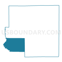
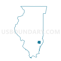
DECKER Voting District, Richland County, Illinois
About
Outline

Summary
| Unique Area Identifier | 574082 |
| Name | DECKER Voting District |
| County | Richland County |
| State | Illinois |
| Area (square miles) | 35.26 |
| Land Area (square miles) | 35.23 |
| Water Area (square miles) | 0.03 |
| % of Land Area | 99.91 |
| % of Water Area | 0.09 |
| Latitude of the Internal Point | 38.63604090 |
| Longtitude of the Internal Point | -88.21367470 |
Maps

Graphs
Select a template below for downloading or customizing gragh for DECKER Voting District, Richland County, Illinois


Neighbors
Neighoring Voting District (by Name) Neighboring Voting District on the Map
- CLAY CITY II Voting District, Clay County, IL
- MADISON 1 Voting District, Richland County, IL
- MADISON 2 Voting District, Richland County, IL
- MT ERIE Voting District, Wayne County, IL
- NOBLE 1 Voting District, Richland County, IL
- NOBLE 2 Voting District, Richland County, IL
- OLNEY 4 Voting District, Richland County, IL
- OLNEY 8 Voting District, Richland County, IL
Top 10 Neighboring County Subdivision (by Population) Neighboring County Subdivision on the Map
- Olney township, Richland County, IL (10,334)
- Noble township, Richland County, IL (1,430)
- Clay City township, Clay County, IL (1,287)
- Madison township, Richland County, IL (819)
- Decker township, Richland County, IL (406)
- Mount Erie township, Wayne County, IL (370)
Top 10 Neighboring Unified School District (by Population) Neighboring Unified School District on the Map
- East Richland Community Unit School District 1, IL (14,052)
- Clay City Community Unit District 10, IL (2,315)
- West Richland Community Unit School District 2, IL (2,250)
Top 10 Neighboring State Legislative District Lower Chamber (by Population) Neighboring State Legislative District Lower Chamber on the Map
Top 10 Neighboring State Legislative District Upper Chamber (by Population) Neighboring State Legislative District Upper Chamber on the Map
Top 10 Neighboring 111th Congressional District (by Population) Neighboring 111th Congressional District on the Map
Top 10 Neighboring Census Tract (by Population) Neighboring Census Tract on the Map
- Census Tract 9779, Richland County, IL (3,768)
- Census Tract 9549, Wayne County, IL (3,334)
- Census Tract 9783, Richland County, IL (3,327)
- Census Tract 9722, Clay County, IL (3,049)